Después de las historias de Inglaterra y España, aquí viene la historia de unos de los estados nacionales más antiguos de Europa que existen continuamente – Hungría. Ya sabes: uno de esos países de los que nadie ha oído hablar nunca.
La poca gente que sí que ha oído de Hungría puede dar fe de que Hungría destaca en el mundo por tres cosas:
Hablamos un idioma insoportable (uno que ningún extranjero sabe dominar)
El emperador Solimán, conocido por algunas almas equivocadas como el Magnífico, ha sido, literalmente, fastidiado hasta la muerte por los húngaros¹
El cubo de Rubik
Por supuesto, hay otras cosas de las que Hungría puede estar orgullosa: como ser el país con la peor hiperinflación del mundo (1946), o, para ser más positivo, tener más premios Nobel, campeones olímpicos, e incluso Gran Maestros de ajedrez per cápita que la mayoría de los otros países… ²
After histories of England and Spain, here comes the history of one of the oldest continuously existing European nation states – Hungary. You know: one of these countries nobody has ever heard of.
The few who have heard of Hungary can attest that she has three claims to international fame:
We speak an unspeakable language (one that no foreigner can master)
The Ottoman emperor Suleiman, known to some misguided souls as the Magnificent, has been literally annoyed to death by the Hungarians¹
Rubik’s cube
There are of course other things that Hungary can boast of: such as being the country with the worst ever hyperinflation in the world (1946), or, on a more positive note, having more Nobel prize winners, Olympic champions and even chess grand masters per capita than most other countries… ²
The Roman province of Hispania in 125 A.D. [Public domain via Wikipedia]As promised in The History of Spain in a Dozen Maps last week, here come the answers to the game of Spot the Towns:
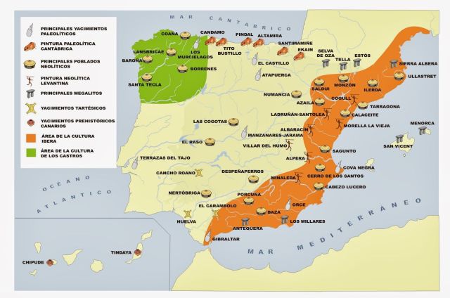
En la edad prehistórica, la Península Ibérica fue, claramente, el lugar donde vivir – como se puede ver en este mapa:
Sitios prehistóricos en España [Gracias a Jesús del blog La Mar de Historias]Bueno. Hace un año tenía una vacación estupenda en Ribadesella en Asturias – uno de esos lugares, donde sólo los españoles (y surfistas americanos) viajan para veranear y donde es, de hecho, es muy útil ser capaz de hablar español. Puedes encontrarlo en el mapa arriba, donde dice Tito Bustillo.
La Cueva Tito Bustillo, que está unos diez o quince minutos de distancia del centro de Ribadesella andando, es un patriomonio de la humanidad de la UNESCO (como la mejor conocida Altamira). Fue descubierto solo en los años 1960 por unos jovenes, quienes, evidentemente, tenían nada mejor que hacer, y le pusieron el nombre de unos de ellos, quien murió en un accidente de espeleología un poco más tarde. En la cueva descubrieron pinturas y herramientas de la Edad de Piedra; las pinturas más antiguos tienen unos 30 mil años. En un rincón hay unas pinturas de… eh… genitales femeninos, que fueron descubiertos, muy apropriadamente, por una miembro del grupo buscando un poco de privacidad para orinar. O, por le menos, eso dice el guía de turismo. 🙂
In prehistoric times, the Iberian Peninsula was clearly the place to be – as attested by this map:
Prehistoric sites in Spain / Sitios prehistóricos en España [Courtesy of Jesús of the blog La Mar de Historias]Now a year ago I had a great holiday in Ribadesella in Asturias – one of those places where only the Spanish (and American surfers) go on holiday to and it’s very useful to be actually able speak Spanish. You can find it on the map above where it says Tito Bustillo.
The Tito Bustillo Cave, some ten-fifteen minutes walk from the centre of Ribadesella, is a UNESCO World Heritage site (like the much better known Altamira). It was only discovered in the 1960s by a group of young people who evidently had nothing better to do and it’s named after one of them who died young in a caving accident. Cave paintings and stone age tools were found in the cave, the oldest paintings being about 30 thousand years old. In a hidden corner there are some paintings of… er… female genitalia which were, appropriately enough, discovered by a female member of the caving party who looked for some privacy to relieve herself. Or at least, so the tour guide says. 🙂
“Dogger. Gale warning.
Gale warning issued 14 March 03:43 UTC¹.
Wind southeast 4 or 5, increasing 6 to gale 8. Sea state moderate, becoming rough or very rough. Weather: occasional drizzle. Visibility good, occasionally poor.”
Shipping Forecast, issued 14 March 17:25 UTC, Met Office
If you ever heard the shipping forecast on BBC Radio 4 (an oddly soothing recital except when it’s inserted into the middle of the nailbiting finish of a test match), then you know that Dogger is one of the forecast zones in the North Sea.
Si has oído, alguna vez, el shipping forecast, es decir, el pronóstico marítimo, de BBC Radio 4 (un recital extrañamente tranquilizador (excepto cuando lo leen durante el emocionantísimo final de un partido internacional de críquet), sabes que Dogger es una de las zonas pronósticas marítimas en el Mar del Norte.
How Britain became an island. Illustration by Francis Lima via Wikipedia [CC-BY-SA 4.0]Up to 8000 B.C. Britain was connected to the Continent by a land bridge and Doggerland was above sea level. But as glacial ice melted after the last ice age, sea levels rose: Britain became an island, while Doggerland went to the bottom of the deep blue sea…
La mapa arriba ilustre como Gran Bretaña se convirtió en una isla.
Hasta 8000 a.C. Gran Bretaña estaba conectado al continente con un ‘puente’ de tierra y el territorio de Doggerland se encontró arriba del nivel del mar. Al terminar la era glacial, el nivel del mar se elevó: Gran Bretaña se convirtió en una isla, mientras que Doggerland se hundió al fondo del mar…
Recommended reading:
⇒ We Didn't Mean to Go to Sea by Arthur Ransome
Close your eyes and imagine one of those old maps which were illustrated with caravels and and fantastic sea animals, where the blank centre of Africa was marked terra incognita and faraway islands were labelled with the warning, Hic Sunt Dracones, Here Be Dragons¹. Is your pulse racing yet? Maps have an intoxicating power for those addicted to travel; historical maps are similarly intoxicating for those addicted to history. Since I’m addicted both to travel and history, you can imagine in what state maps leave me…
(Hic!)
Aquí hay dragones
Cierra los ojos e imagínate uno des esos mapas antiguos, ilustrados con carabelas y animales marinos fantásticos, donde el centro en blanco de África se marcaba terra incognita e islas del ultramar se marcaban con la advertencia, Hic Sunt Dracones, aquí hay dragones¹. ¿Te acelera el pulso? Mapas tienen un poder embriagador para los que son adictos al viaje, y mapas históricos tienen un poder semejante embriagador para los que son adictos a la historia. Como que yo soy adicto a ambos, puedes imaginarte en que estado me quedo después de admirar unos mapas…
(¡Hip!)
Map of the Pacific Ocean by Ortelius, 1589. The ship drawn out of all proportions in the southeast quadrant is Magellan’s Victoria, the first ship to circumnavigate the globe. [Public domain via Wikimedia Commons]Which is perhaps why it occurred to me the other day that there are worse ways of summing up a country’s history than by examining a handful of telltale maps. A few countries immediately spring to mind as excellent candidates for this kind of exercise: I’ll start with my adopted country, England.
Quizás por eso me ocurrió la idea de contar la historia con un puñado de mapas elocuentes. Unos países se ofrecen inmediatamente como candidatos excelentes para este tipo de ejercicio: voy a empezar con mi país adoptivo, Inglaterra.
And since this pretends to be a book blog, I’ll throw in a handful of book recommendations too!
Y como eso pretende ser un blog de libros, ¡voy a añadir unos recomendaciones de libros también!
I hope you’ll enjoy The History of England in a Dozen Maps (coming tomorrow), the first post in what I hope to turn into a new series under the title of Mapping History.
Espero que os guste La historia de Inglaterra en una docena de mapas (saldrá mañana), el primer post en un series nuevo que intento con el título Mapping History (Historia en mapas).
Notes:
¹ Wikipedia tells me that hic sunt dracones doesn't actually pop up on any map. Well, it's still a good phrase. :) It does appear, however, on the Hunt-Lenox Globe near the eastern coast of Asia and it might have been referring to the Komodo dragons. It might have.

¹ Wikipedia me dice que la frase hic sunt dracones, de hecho, no aparece en ningún mapa. Bueno, aun así se queda una frase encantadora. Se aparece, sin embargo en el Globo de Hunt-Lenox Globe, cerca de la costa oriental de Asia y pudiera referirse a los dragones de Komodo. Pudiera, dije.